Summary
Changes in global climate and human activities are forecast to increase the probability of vector-borne diseases (VBD) spreading into previously unaffected areas. The wide spread of West Nile Virus into areas of North-eastern Italy formerly free from such diseases confirms the reality of this threat.
This situation prompts fine-tuned surveillance activities for early detecting re-activation and/or new introductions of the virus. It has been reported that the identification of WNV circulation in the mosquito vectors is directly related to the risk of the virus spreading to humans and other hosts. Therefore, entomological surveillance is paramount and should be given particular relevance when designing the framework for WNV surveillance plans. Entomological surveillance may aim both to assess the presence of specific VBD vectors in an area and to detect any circulation of aetiological agents in the vector populations.
The project
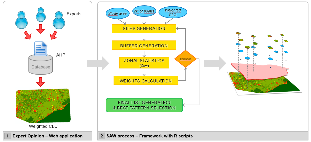
The main aim of the present project is to provide a GIS toolbox, based on the Multicriteria – Spatial Decision Support Systems (MC-SDSS). MC-SDSS combines Geographic Information Systems (GIS) and Multicriteria Analysis, to support environmental management that could be related to epidemiological issues.
Simple Additive Weighting (SAW) has been integrated in the toolbox in order to evaluate the importance in the phenomena explanation. Expert elicitation based on the Analytic Hierarchic Process (AHP) allows to define weights for each variable considerate. The project is focused on WNV mosquito vectors. Nevertheless the proposed framework could also be used both for the surveillance of other Vector Borne Diseases and as ancillary information in other biological studies by conveniently re-modulating the land use weighting and/or including additional environmental factors.
The Framework
Analysis
Analysis are developed in R, and all scripts producted are published from GitHub.
Contacts
Send an email to gis@izsvenezie.it